UK temperatures set to touch 20C this week with little rain on the horizon

- Published
April showers look like being in short supply for at least the next week as high pressure dominates the UK forecast.
There will be plenty of spring sunshine which could push temperatures up to 20C (68F) in some southern areas.
Eastern coasts will often be cooler with a breeze blowing from the chilly North Sea, bringing low cloud and fog at times.
A few showers are possible but there is little sign of any widespread wet weather in the outlook.
Spring sunshine with a chilly breeze
Tuesday will be the start of a string of largely dry days with most parts of the UK seeing sunny spells, albeit with some patches of cloud.
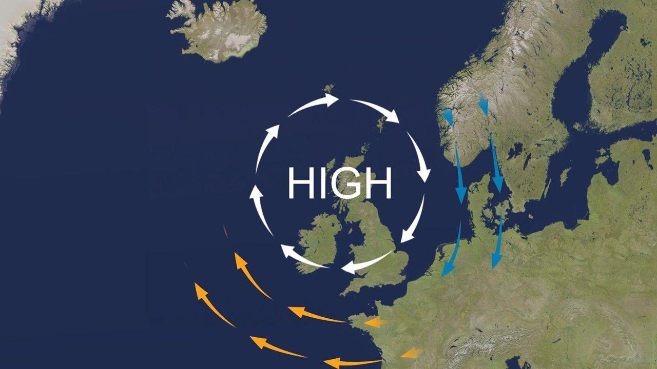
High pressure will be sitting to the north of the UK - rather than directly overhead - meaning an easterly breeze will blow across the country.
This will hold temperatures back a little, reaching highs of 10-15C (50-59F) on Tuesday afternoon - about average for this time of year.
A zone of low cloud, mist and fog is likely to spread across Shetland and Orkney, perhaps reaching the north-east of the Scottish mainland by the end of the day.

Most places will be sunnier on Wednesday - away from the north-east of the UK
Those murky conditions will roll further south by Wednesday with low cloud and sea fog expected along the coasts of eastern Scotland and north-east England.
This will make it feel quite chilly in places.
There may be a few showers in the far south-west of England where it will turn rather windy for a time.
In other areas the middle of the week should bring largely blue skies, with temperatures in sunny parts of Wales, the Midlands and southern England set to climb to around 17C (63F).
Highest temperatures later in the week
By Thursday and Friday winds will ease a little and, as sunny conditions continue, temperatures will rise even further.
Many areas will see highs of 15-19C (59-66F) with 20C (68F) possible in the south.

Eastern coasts of Scotland and England will remain rather chilly at 9-13C (48-55F)
At the moment it looks very unlikely that the UK will exceed the 26.6C (79.8F) recorded at Kew Gardens, London, on 8 April - the warmest day of the year so far.
However, the Sun is growing increasingly strong at this time of year, meaning high UV levels are expected.
Pollen levels will be moderate or high in many places.
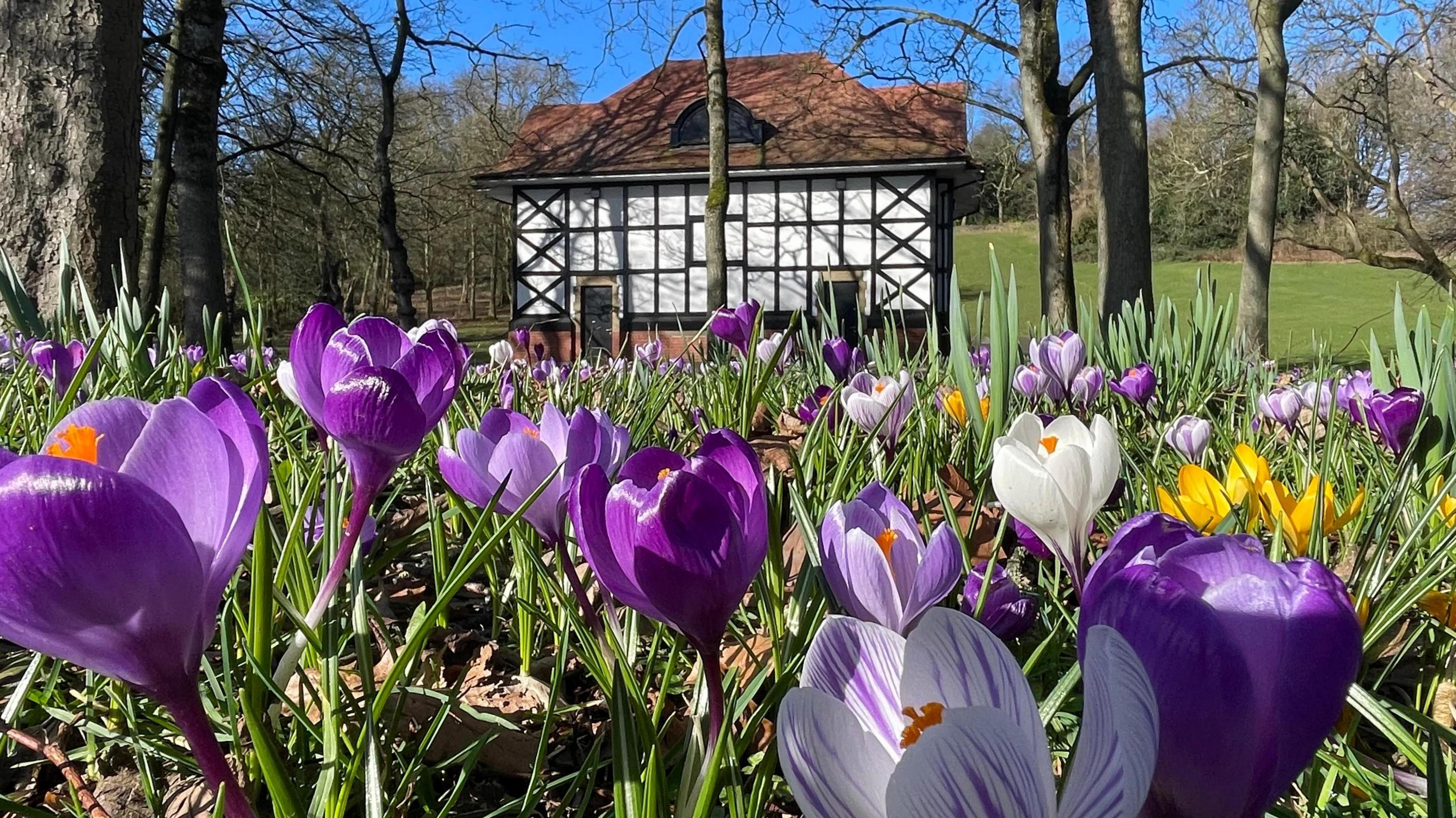
Vibrant spring flower displays due to warm spring sunshine and a wet winter
- Published2 days ago
Frost and fog
While the days will become fairly warm, the nights will be a different story.
Overnight temperatures will drop close to freezing throughout this week meaning some places could see a touch of ground frost.
This is a common feature of spring weather with warm days interspersed with cold nights - giving a large diurnal range.
The same clear skies that allow the Sun to warm the air during the day also allow that energy to radiate away at night.
And the nights are still long enough to give temperatures plenty of time to drop.
Some morning fog patches are also likely especially by Friday and into the weekend.
When will the weather change?
Throughout this week the jet stream will be meandering across the Atlantic, bending northwards and southwards.
This will allow high pressure to remain across the UK, blocking the progress of rain-bearing weather systems - almost like an atmospheric traffic jam.

The jet stream will steer clear of the UK this week, waving around erratically
For widespread rain to return, the jet stream would need to break back through that block and at the moment there is no real sign of that happening over the weekend - or indeed during the early part of next week.
A few showers are likely but broadly the weather looks like remaining largely dry for the foreseeable future - although temperatures may drop back a little.
For some of us it will mark a continuation of what has been a dry April so far.
Parts of eastern England have seen just 2% of the rainfall they would expect in a typical April.
In contrast, some areas of Scotland and Northern Ireland have already had more than 100% of their average rainfall for the whole month, meaning a drier spell may be welcome.
You can keep an eye on the prospects for wet weather further ahead, into May, by checking our monthly outlook.
And the hour-by-hour forecast for your local area is always available on the BBC Weather website and app.
- Published7 April 2022
- Published10 April
- Published14 August 2025