Summary

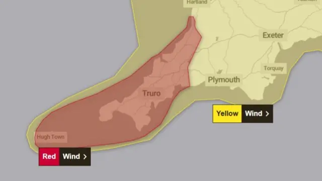
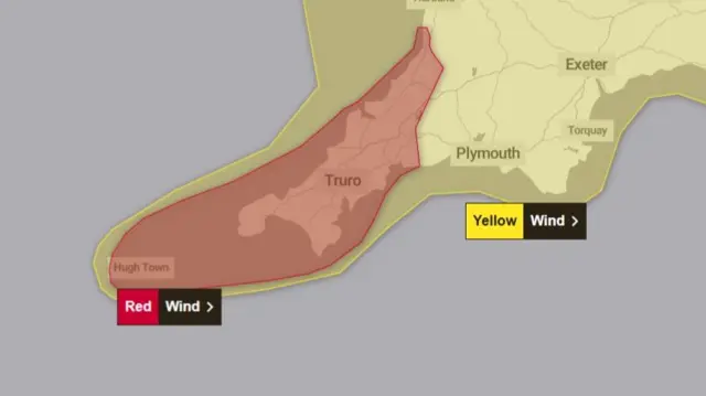
  1. 'We're used to being battered, but this is serious', says Isles of Scilly residentpublished at 17:31 GMT 8 January

    Jack Grey
    Live reporter

    Samantha Mallon, of Toots Taxi, in a slefie with windswept blonde hair
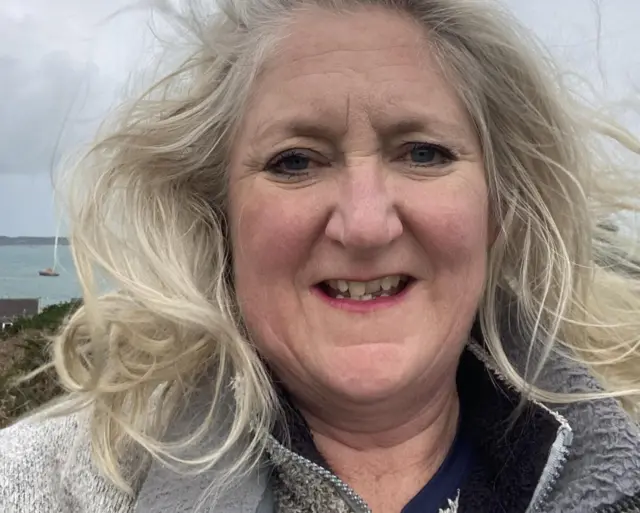
Image source, Toots Taxi

    Samantha Mallon of the Isles of Scilly says she and her neighbours have prepared as best as they can ahead of the "exceptional wind speeds" forecast for the area later this evening.

    Samantha, 53, runs one of two taxis on St Mary's, the largest island of the archipelago which is at the centre of the Met Office's red wind warning - with forecasters warning of gusts in excess of 100mph.

    "We tend not to get nervous," says Samantha. "We're a granite outcrop in the middle of the Atlantic, we get battered all the time... but this is the time where we do need to be heeding these warnings."

    She tells me she's fastened down her garden furniture and has turned the heating on full blast in her home, to keep some warmth in the event of a power cut, and has also stocked up on candles.

    "Most of the pubs are shut, the school's closed, the co-cop is shut, everyone is being sensible, we just have to hunker down.

    "If the power does go out, I will drink some gin."

  2. Up to 30cm of snow in Wales and the West Midlands - Met Officepublished at 17:18 GMT 8 January

    A map shows yellow, amber and red weather warnings across the UK. A red warning for wind is in place in parts of Cornwall while an orange warning for snow covers a horse shoe shape in Wales and the West MidlandsImage source, Met Office
    Image caption,

    The Met Office has updated its weather warnings ahead of Storm Goretti

    The Met Office has updated an amber weather warning covering parts of the West Midlands and Wales as heavy snow is likely to lead to dangerous travelling conditions.

    The warning now includes Wrexham, Stafford and parts of Flintshire.

    A yellow snow warning has also been extended north to cover parts of Cheshire.

    There could be up to 30cm of snow in some locations, especially on hills above 200m in Wales and the Peak District.

    There could be 10 to 15cm of snow in a fairly wide area, the Met Office adds.

    The forecaster says snow will ease through the course of Friday morning, turning to rain or sleet at times at low levels.

    But disruption is likely to continue into Friday after the snow stops falling.

  3. Rare fogbow which 'disappeared in seconds' captured on camerapublished at 17:05 GMT 8 January

    A railway is covered in snow next to a white and brown picket fence. A white 'fogbow' can be seen above a snow covered building and trees.Image source, Jodie Bews

    Jodie Bews took this photo of a fogbow earlier today in Alford, Aberdeenshire.

    They are a rare meteorological phenomenon, also known as a white rainbow, cloud bow, or a ghost of a rainbow.

    Unlike a classical rainbow which is formed when sunlight interacts with raindrops, a fogbow forms when sunlight interacts with much smaller water droplets found in fog, mist, or cloud.

    Jodie says she was "absolutely delighted" to capture it on camera because it "was only there for seconds" near to the Alford Community Valley Railway.

  4. 'We were told to leave work early because of the storm'published at 16:52 GMT 8 January

    Will Vernon
    Reporting from Birmingham

    A sign warns that trains are running on a reduced timetable due to Storm Goretti. An electronic train timetable can be seen in the background

    I'm at Birmingham New Street train station, where changes and cancellations are expected after 19:00 due to the storm.

    Hoping to avoid disruption, many passengers tell me they’ve changed their travel plans to get earlier trains.

    Chiny, a 39-year-old government worker, is heading home to Leeds a day early to try and beat the weather.

    “We were having a work meeting but it was ended early and everyone was told to go home because of the storm,” he says.

    University of Oxford student Kat, 22, was passing through Birmingham on her way home to Leicester and had to get an earlier train after hers was cancelled.

    “My mum has offered to pick me up from the station which she normally doesn’t do, so maybe that’s an indicator of the seriousness of it,” she said.

    Also at the station today was The Traitors presenter Claudia Winkleman, who was filming an episode of Channel 4’s The Piano, alongside commuters waiting anxiously for news of their cancelled journeys.

  5. 'It'll be extremely busy tonight': Volunteer 4x4 drivers prepare in West Midlandspublished at 16:39 GMT 8 January

    Phil Mackie
    Reporting from Birmingham

    Geoff Lake wearing hi vis in front of his 4x4 volunteer vehicle

    The major roads and motorways around Birmingham are particularly busy already as many people have left work early, so rush hour today began at around 14:00 GMT.

    Getting ready to help NHS workers tonight is Geoff Flegg, from West Midlands 4x4 Response.

    The charity provides support to the emergency services and will have 36 responders on duty as an amber weather alert comes into force.

    “It’ll be extremely busy tonight. If this snow hits we’ll be called out all over the West Midlands from Stoke-on-Trent all the way down to Stratford,” he says.

    The volunteers will most likely be working through the night to ensure staff can get in for their shifts, and also get home safely.

  6. The latest weather warnings around the UKpublished at 16:25 GMT 8 January

    A map with yellow, amber and red labels showing where in the country have been issued with weather warningsImage source, Met Office

    Eight weather warnings for snow, wind and rain have been issued by the Met Office across the country, and are either already in place are due to begin shortly. They are:

    • A red warning for wind in Cornwall and Isles of Scilly where around half a million people are being sent an emergency weather alert
    • An amber warning for snow for parts of the West Midlands kicks in at 20:00 and has now been expanded to include Wrexham, Stafford and part of Flintshire
    • A yellow weather warning for snow covering parts of Shetland, Scotland
    • A separate yellow weather warning for snow and ice covering parts of Scotland and North East England
    • A yellow warning for rain for parts of Suffolk and areas of the East Midlands comes into force at 18:00
    • Areas of the north of England, south west England and south west Wales are also covered by a yellow snow warning from 17:00
    • Much of west Wales is covered by a yellow warning for rain
    • While a yellow warning for wind covers areas of south west England

    Separately, forecasters in Jersey have issued a red weather warning, while people in Guernsey have been urged to stay at home.

  7. Guernsey tells people to stay home as major incident declared in Jerseypublished at 16:18 GMT 8 January

    A sign at a station warns that a red weather warning is in place due to Storm Goratti and that the last bus will depart at 19:20 on Thursday
    Image caption,

    Jersey bus services are finishing early due to the warning

    People living in the Channel Islands have been told to stay at home during Storm Goretti as strong winds are expected to hit the region this evening.

    A major incident has been declared in Jersey, where a red wind warning issued by local forecasters remains in place.

    Wind speeds on the island are expected to peak between 19:00 GMT and 3:00 GMT om Friday, the Government of Jersey says, and a major incident will come into force during that period.

    Jersey Met said the storm would bring heavy rain and showers from 16:30 GMT alongside force 11 winds gusting up to 90mph (144km/h) from 20:00.

    It has asked the public to only call 999 overnight if there is an emergency and people should only visit the Hospital Emergency Department if there is a "genuine medical emergency".

    Schools will be open on Friday unless people hear otherwise, it adds.

    Guernsey airport will also close at 18:00 GMT and is likely to open late on Friday morning.

    The Government of Guernsey says there could be extremely high winds and has told islanders to be home and safe by 18:00 before the weather deteriorates.

  8. Around half a million people to receive emergency weather alertpublished at 16:01 GMT 8 January

    Two emergency alerts are being sent to around half a million people across the Isles of Scilly and Cornwall after a rare red weather warning was issued by the Met Office.

    The first alert was sent at around 15:00 to people in the Isles of Scilly, while the second will be sent at around 17:00 to people in Cornwall.

    The government says compatible phones will make a "loud siren-like sound even if they are set on silent", which will last for about 10 seconds.

    And people will receive a message from the government containing information about the red warning and how to stay safe.

    Mass weather alerts sent by phone are rare in the UK - only four such weather alerts have been sent out in the past. The last alert was sent to 4.5 million people in Scotland and Northern Ireland in response to Storm Eowyn last year.

  9. Rare red wind warning comes into force in South Westpublished at 16:00 GMT 8 January
    Breaking

    A red weather warning for wind covering much of Cornwall and the Isles of Scilly is now in effect.

    It is scheduled to last until 23:00 GMT on Thursday, with forecasters warning of "exceptionally strong winds" in excess of 100mph in exposed areas.

    The Met Office advises residents to avoid travelling by road, secure loose items and stay indoors whenever possible.

    Weather warning map showing red warning over south-west cornwallImage source, Met Office
  10. Watch: The latest BBC Weather forecastpublished at 15:54 GMT 8 January

    Media caption,

    Watch: Latest weather forecast ahead of Storm Goretti

  11. 'It doesn't get higher than this': Red warning due to kick inpublished at 15:44 GMT 8 January

    With the Met Office issuing a "danger to life" warning across Cornwall and the Isles of Scilly, BBC weather presenter Stav Danaos explains what those in the area should be doing.

    As a reminder, that very rare red warning is due to come into place at 16:00.

    Media caption,

    Red wind warning issued for south-west England

  12. In pictures: The calm before the stormpublished at 15:26 GMT 8 January

    Ice climbers head out from Featherbed Moss in the Peak District as the wintry weather continues in the UK The UK is braced for heavy snowfall and strong winds from Storm Goretti with amber weather warnings issued across the country.Image source, PA Media
    Image caption,

    Before conditions worsen, these two hikers braved a snowy Featherbed Moss in the Peak District

    A Kingfisher eats a fish during calm weather on a river near Dover in Kent. The UK is braced for heavy snowfall and strong winds from Storm Goretti with amber weather warnings issued across the country. Picture date: Thursday January 8, 2026.Image source, PA Media
    Image caption,

    This Kingfisher was spotted in Dover earlier, where conditions are expected to worsen this evening

    A woman takes a picture of dogs in Camridgeshire. The UK is braced for heavy snowfall and strong winds from Storm Goretti with amber weather warnings issued across the country. Picture date: Thursday January 8, 2026Image source, PA Media
    Image caption,

    In Cambridgeshire, some extremely well behaved puppies posed for a picture in the park

  13. UK weather warnings: What you need to knowpublished at 15:15 GMT 8 January

    When dangerous weather is forecast, a weather warning will be issued by the Met Office, the UK’s national weather service.

    Weather warnings are given a colour – yellow, amber or red - with yellow being the lowest, and red the most serious. The colour assigned depends on a combination of two thing; the impact the weather is likely to have and the likelihood of it happening.

    • Yellow warnings: Are the ones you will see most often. They give you a heads up that severe weather is possible and to start planning for impacts to either travel, power or property
    • Amber warnings: Mean travel disruption is more likely and there is a potential risk to life and property
    • Red warnings: These are rare, and have only been issued a handful of times in recent years - including today for parts of south-west England. They mean the Met Office believes that dangerous, potentially life-threatening weather is expected imminently and you should immediately take action to keep yourself and other safe
    A grid with colours ranging from green to yellow to orange to red. The yellow box is ticked
    Image caption,

    An example of a Met Office warning matrix. Here, the position of the tick indicates that a yellow weather warning would be issued

  14. Schools close and trains cancelled as Goretti nears south-west Englandpublished at 14:59 GMT 8 January

    Almost 100 schools have closed early across the Cornwall as Storm Goretti nears, bringing with it extremely powerful winds that have triggered a rare red weather warning.

    Newquay RNLI says residents can expect roofs to be blown off, roads, bridges and railway lines closed, flying debris resulting in danger to life and power cuts affecting services such as mobile phone coverage.

    Cornwall Council says exposed coastal areas will be particularly dangerous due to "large waves and strong winds". These are expected to throw material onto coastal roads, sea fronts and homes.

    National Rail announced earlier that all trains are to be suspended from 18:00 GMT this evening until Friday morning. Replacement road transport will not be available due to the expected conditions on the road.

  15. Goretti winds stronger than other storms in recent memory - Met Officepublished at 14:48 GMT 8 January

    We've just had some more detail from the Met Office, following its issuing of a rare "danger to life" red wind warning.

    It says the strongest winds are expected in the west of Cornwall and the Isles of Scilly. In coastal areas, gusts could surpass 100mph and bring very large waves.

    "These are exceptional wind speeds and could be stronger than other storms in recent memory," the Met Office says.

    The far south-west of Wales and other parts of southern England will also see strong winds, with gusts of 50-60mph, but are not included in the red warning.

    The Channel Islands are expected to experience "even stronger winds", with Jersey's weather agency also issuing a red warning.

    In both Jersey and Guernsey, people have been told to stay at home this evening and overnight for their own safety.

  16. How unusual is a red weather warning?published at 14:35 GMT 8 January

    Simon King
    Presenter and meteorologist, BBC Weather

    A red weather warning is the most severe Met Office warning and will only be issued in the most extreme circumstances.

    As Storm Goretti moves closer to the south-west of England there has been increased confidence that gusts of 100mph or more in exposed areas will be seen in parts of Cornwall and the Isle of Scilly later this afternoon.

    These violent and dangerous gusts will damage buildings, bring trees down and create a lot of flying debris. Coastal areas will also be particularly dangerous due to large waves.

    There is a danger to life and the advice is to stay away from the coast, take action to protect yourself and stay indoors if you can.

    The last Met Office red weather warning was issued in January 2025 during Storm Éowyn for the central belt of Scotland.

    Before that, in south-west England and south-west Wales a red warning was issued during Storm Darragh in December 2024 for gusts exceeding 90mph.

  17. What does the red weather warning in south-west England mean?published at 14:25 GMT 8 January

    Chris Fawkes
    BBC Weather

    The Met Office has just issued a red warning for wind in Cornwall and the Isles of Scilly from 16:00 until 23:00.

    Damaging gusts of wind are expected to reach 80 to 100mph, perhaps even stronger, with a risk of structural damage to some buildings, transport disruption along with the potential for power cuts.

    It's advisable to stay indoors during the peak of this storm and keep away from coastal areas where dangerous waves will bring additional hazards.

    Storm Goretti is an example of a "weather bomb - this is where pressure falls by 24hPa within 24 hours, which reasonably common for Atlantic low-pressure systems.

    Goretti will also bring disruptive snow for some this evening and overnight.

  18. Met Office issues rare 'danger to life' wind warningpublished at 14:17 GMT 8 January

    Weather warning mapImage source, Met Office

    The Met Office has warned that powerful winds in Cornwall and the Isles of Scilly will likely cause damage to buildings and homes, flying debris and bring down power lines this evening, resulting in a "danger to life".

    The unusual red warning which has just been issued kicks in at 16:00 and lasts until 23:00.

    Forecasters say it is expected travel will be severely disrupted, with power cuts affecting other services like mobile phone coverage.

    The Met Office says strong winds are expected to "suddenly jump" to as strong as 100mph later tonight.

    Return to the latest post
  19. Rare red warning issued for extreme winds in parts of south-west Englandpublished at 14:07 GMT 8 January
    Breaking

    A rare red weather warning has just been issued for the Isles of Scilly and Cornwall.

    The Met Office says parts of the south-west of England will experience "exceptionally strong winds" later due to Storm Goretti.

    The warning is in place from 16:00 GMT until 23:00. We'll bring you more on this in a couple of minutes.

  20. No snow on your weather app? Why that doesn't tell the whole storypublished at 13:55 GMT 8 January

    Simon King
    Lead Weather Presenter, BBC Weather

    A screenshot shows weather symbols for the next three days: cloudy, sun and rain, and sun and sleetImage source, BBC Weather
    Image caption,

    Symbols don't always tell the full story during complex weather

    If you’re in a warning area for snow but looking at your weather app and just see rain or sleet symbols, you might be confused about the forecast.

    This reflects the complexities of forecasting snow in the UK.

    While the UK has been experiencing cold Arctic air, Storm Goretti contains milder air with a lot of rain.

    This creates a battleground of the air masses and that makes it difficult to work out at a local level whether mild air wins and you get rain or sleet, or, the cold air wins and you get significant snow.

    Fractions of a difference in temperature, altitude or intensity of precipitation will tip the balance between snow or sleet and rain.

    While apps like the BBC Weather app, which are used by millions of us every day, are normally very good at giving you an idea of how to prepare, in these complex situations, they don’t give the whole picture.

    Data in the app has to be clear cut on showing either rain and sleet or snow. Whereas humans can asses the risk, knowing the bigger picture and limitations of the data and give a more useful explanation.

    We are confident that within the broader area of Wales, the Midlands and parts of northern England, there will be significant snow tonight, especially over higher ground.

    Though locally within this area, you may just see wet snow, sleet or rain.