|
|
Stiperstones - Visitor Guide
|
| Address: |
The Stiperstones National Nature Reserve, south of Minsterley,
Shropshire.
|
| e-mail |
enquiries@naturalengland.org.uk |
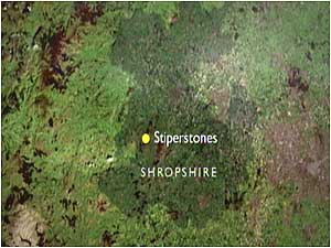
| Maps: |
Map
of the Stiperstones area |
| Ordnance Survey: |
OS reference: SJ 375 055 |
| Key attractions: |
Geology, Bronze Age monuments and an interesting mix of plant and
animal communities with several species being found at the edge
of their natural range.
|
| Essential kit: |
Walking shoes and weatherproof clothing.
Bear in mind that that the weather can change quickly on this upland
area - the ridge is also subject to many lightening strikes so check
the weather forecast before setting out.
|
| Nature watching: |
Great walking country - Stiperstones Stomp (5 miles) - there are
important concentrations of unimproved grasslands, showing gradations
from upland acid grassland to neutral grasslands on lower slopes.
The Stipertones lie within the Shropshire Hills Area of Outstanding
Natural Beauty and is also part of the Hollies Site of Special Scientific
Interest (SSSI).
Moth watching.
|
| Facilities: |
None provided
|
| Access: |
Disabled access: There are a number of shorter walking routes and
an all-ability trail offering wheelchair access.
|
| Getting there: |
Signposted roads lead up from the A488 south of Minsterley.
There is a choice of car parks, with English Nature's National
Nature Reserve car park at the very top, adjacent to the all-access
path and the route leading up towards the ridge.
The Long Mynd & Stiperstones Shuttle also operates on Saturdays,
Sundays and Bank Holiday Mondays between April and October.
|
| Opening times: |
All year round
|
| Charges: |
No admission charges |